On-Demand Webinars

Connecting Reconnaissance, Response and Recovery Missions with TerraGo

Introduction to R3 Mobile Data Collection Application

June 12, 2018

Watch this on-demand webinar for a live demonstration of the recently released TerraGo R3 mobile application – now available on the NGA App Store, and learn how to utilize this application for a variety of field data collection activities.
WATCH NOW

TerraGo Geospatial Solutions for the Last Tactical Mile

May 22, 2018

Watch this on-demand webinar to learn more about TerraGo’s dissemination and collaboration software solutions for Defense and Intelligence applications including:Register for this upcoming webinar to learn more about TerraGo’s dissemination and collaboration software solutions for Defense and Intelligence applications including:
WATCH NOW

Building Smarter Cities with TerraGo Streetlights

April 17, 2018

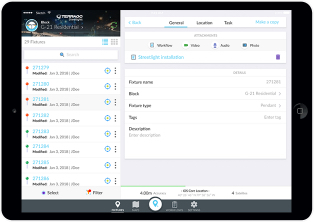
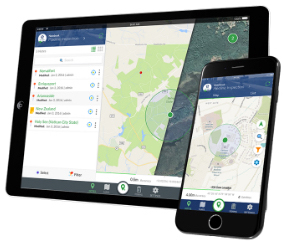
Watch this on-demand webinar to see a live demonstration of TerraGo Streetlights and learn from real-life projects, including Chicago, one of the world’s largest smart streetlight projects, and Richmond Hill (Toronto), which was chosen for a Smart 50 Award and reduced commissioning times from 2 days to under 2 minutes.
WATCH NOW

BAE Systems Launches GXP InForm Mobile Application for GXP Xplorer

February 21, 2018

Watch this on-demand webinar to see how the new GXP InForm application connects mobile field personnel and command operations to annotated, actionable imagery from GXP Xplorer to improve situational awareness, location-based reporting and cloud-based collaboration.
WATCH NOW

Build Enterprise Mobile Apps In Minutes with TerraGo Magic

October 10, 2017

Join this webinar to learn about some of the mobile applications already created and published by our customers and to see a live demonstration of how to:
  • Create mobile apps for inspections, asset management, service dispatch, surveying or any business workflow and for any industry;
  • Customize with your logo, colors, language and labels;
  • Configure your application from a list of field-proven features;
  • Publish apps to iTunes AppStore, Google Play and the Cloud with the click of a button.
WATCH NOW

Introducing P.L.A.N.I.T. Mobile Data Collection Platform from Western Data Systems

September 22, 2017

Register for this webinar, co-hosted by WDS and TerraGo, to learn about the recent partnership and how to:
  • Capture field data in real-time with the WDS P.L.A.N.I.T. mobile app and Trimble GNSS receivers and Laser Technology Range Finders;
  • Customize mobile forms, maps, apps and workflows for any surveying mapping or data collection
  • requirement;
  • Create custom base maps for use offline;
  • Synchronize field data across project teams and headquarters; Integrate data and automate workflows with ArcGIS and other enterprise platforms.
WATCH NOW

Advanced Mobile Data Collection Finds the Range with Laser-Precision

August 22, 2017

In this on demand webinar with TerraGo and LTI, you’ll learn about the recent partnership and how to:
  • Connect laser range finders to TerraGo-enabled Android or iOS apps;
  • Collect location-tagged field data with GPS offset mapping to improve data collection efficiency and safety;
  • Capture a feature or asset’s coordinates without having to physically occupy its position;
  • Customize mobile forms, maps, apps and workflows for any industry or unique workflow;
  • Synchronize field data across project field teams and headquarters in real-time.
WATCH NOW

TerraGo Mobile Apps add Mobile Mapping Features and Laser Rangefinder Integration

August 16, 2017

Watch this on-demand webinar to see a live demonstration of the latest features available with TerraGo Magic Apps and TerraGo Edge 4.1 including:
  • Enhanced Mobile Mapping Features: Turn-by-Turn navigation and waypoint guidance for finding off road assets and infrastructures;
  • Laser Rangefinder Integration: Rapidly capture high-accuracy data in remote locations with professional grade laser positioning; And more…
WATCH NOW

Advanced Mobile GNSS Field-to-GIS Solution

July 18, 2017

TerraGo and Seiler Instrument have recently partnered to deliver a powerful, mobile GPS collaboration app to organizations that need the high-accuracy of a Trimble GNSS device paired with a flexible, easy-to-use data collection app for their unique workflow. Watch this on-demand webinar, hosted by Seiler Instrument and TerraGo, to learn about the recent partnership and how to:
  • Capture field data in real-time with the Seiler Field-to-GIS app and Trimble GNSS;
  • Customize mobile forms, maps, apps and workflows to meet your unique requirements;
  • Create custom base maps for use offline;
  • Synchronize field data across project teams and headquarters;
  • Integrate data and automate field workflows with ArcGIS and other enterprise platforms.
WATCH NOW

Building Custom Cloud-Based Mobile Apps for Any Mission

July 11, 2017

Watch this on-demand webinar and learn how to:
  • Easily create mobile apps for any project or mission and in any environment;
  • Customize your app with your brand, language, labels and features;
  • Enable secure collaboration between teams, headquarters and the field with a custom, private-cloud application;
  • Create and leverage GeoPackage for interoperability in the DoD, the IC, Friendly Foreign Militaries, NGOs, Federal Civilian and in between agencies;
  • Publish apps to AppStore, Google Play and the Cloud.
WATCH NOW
1
2
3
4
5